


Dowth : Passage Tomb
Visit Notes
Sunday, 19th August 2001
What a beautiful place. When I visited Newgrange (County Meath) I was told that Dowth had been closed for 15 years and was not accesible to the public. I am so glad that I came along to see if I could just get a glimpse the site by peering over the hedge. Dowth is open and offers stark contrast to the over renevated Knowth (County Meath) and Newgrange making it so worth a visit.
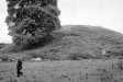
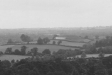
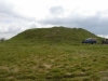
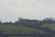
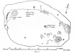
As you approach from the road you are immediately overwhelmed by the 15m high cairn in front of you, lying in neglected deterioration. Glorious! The top of the mound is hollowed out exposing some of the rocks that make up its structure. From the top you can get a beautiful view of Newgrange standing proud on its ridge. From here the restoration of Newgrange is worth it.
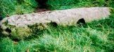
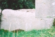
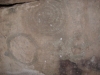
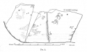
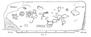
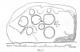
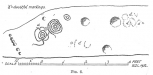
Walking around to the right you will come to the entrance passages of the two tombs that are within Dowth. The one is easy to dismiss as you can not see the entrance: it has slipped into a neighboring field and is surrounded by a wall. There used to be a ladder down, but that has now gone and you can no longer enter. Near to that is a souterrain that actually cuts across the passage and is easily mistaken for the main entrance, again this is blocked off. Continuing around you will see the opening to the second, smaller tomb. In front of it, still half in the ground is the carved entrance stone, a spiral and two cup marks visible.
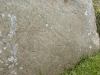
As you continue many of the kerb stones are exposed, cracking and flaking into oblivion, the ones that are carved are fading and weathering quickly. At the rear of the hill are three enormous carved stones. On the last one you can just make out seven sun motifs. This stone, unusually, has carvings on the rear too.
I fell in love with Dowth and will go back there as often as possible.
Click Thumbnail to View Full Size Image
_______
Friday, 12th April 2002
This was such a great trip to one of my favourite sites. The beauty of Dowth after Newgrange (County Meath) and Knowth (County Meath) is one of the best experiences out.
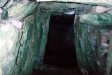
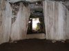
To add to the enormous thrill of being back here I was able to obtain the key to the south passage for this trip and so treat myself and my friends to someting really special.
We had forgotten to take a torch but our eyes soon adjusted to the gloom and it became quite easy to see in the main chamber . However, we had to use the camera flashes to find where stuff was in the sub-chamber.
I love Dowth even more now.
Click Thumbnail to View Full Size Image
______

Friday, 23rd March 2007
After revisiting Townley Hall (County Louth) and noticing that Dowth is so dominant on the southern skyline from there I had to pop over and mooch around. I didn't stay long, because there were some workmen there that looked as though they wanted to do something, but weren't going to do it until I left.
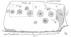
There is a very nice looking information sign near to the entrance now and you can get into the field where the large kerbstone is that used to stand in front of the entrance to the north passage.
At the rear of the mound the large kerbstones with the sun emblems on them have been fenced off. This, along with the presence of a small ticket-office-type cabin by the entrance worries me. I hope they aren't going to force people to visit Dowth via the Newgrange Visitor Centre. It would be a travesty if people were stopped from coming here whenever they liked.


Thursday, 24th May 2012
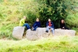
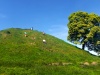
Once again it proved a popular choice to visit Dowth after Knowth and Newgrange. Everyone seems to love the 'natural' state of Dowth. The large tree on the side of the cairn is getting truly massive. It's an iconic photo now, but I wonder how long they can leave it there.
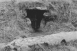
We had a late picnic lunch here, but this wasn't exactly easy. The ground around the mound is littered with nettles and thistles. There are sheep in the field, but they obviously know better than to eat nasty plants like these.

Like this monument
Marked Sites
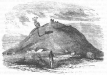
Old Images
Click Thumbnail to View Full Size Image
 _
_ _
_ _
_ _
_ _
_ _
_ _
_ _
_ _
_Directions
Take the N2 from Dublin to Slane and then follow the N51 east. After about 5 km you will reach signs leading the way to Dowth.
Miscellanea
I was informed on Sept 7th 2003 that the key to the Southern Chamber is no longer given out to the public.
Random Gazetteer
A Selection of Other Passage Tombs
External Links
Knowth.com
A great site specialising in the megalithic passage tombs of Newgrange, Knowth, Dowth, Fourknocks, Loughcrew and Tara.Click here to visit this site
About Coordinates Displayed
|
This is an explanation of (and a bit of a disclaimer for) the coordinates I provide. Where a GPS figure is given this is the master for all other coordinates. According to my Garmin these are quite accurate. Where there is no GPS figure the 6 figure grid reference is master for the others. This may not be very accurate as it could have come from the OS maps and could have been read by eye. Consequently, all other cordinates are going to have inaccuracies. The calculation of Longitude and Latitude uses an algorithm that is not 100% accurate. The long/lat figures are used as a basis for calculating the UTM & ITM coordinates. Consequently, UTM & ITM coordinates are slightly out. UTM is a global coordinate system - Universal Transverse Mercator - that is at the core of the GPS system. ITM is the new coordinate system - Irish Transverse Mercator - that is more accurate and more GPS friendly than the Irish Grid Reference system. This will be used on the next generation of Irish OS maps. |


Page loaded from cache: (Generation time: January 18 2020 01:11:16.)