


'Knowth - Rock Art' : Rock Art
This is a subsite of:
Visit Notes
Friday, 12th April 2002
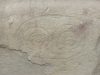
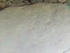
I have added this section because the amount of pictures for Knowth would have been silly if I'd have included the Rock Art on the main page.
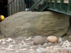
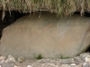
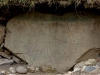
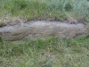
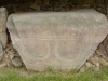
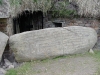
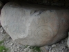
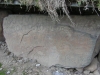
The wealth of carving at Knowth is unbelievable and is still estimated to represent over 30% of Europes passage tomb art.
Click Thumbnail to View Full Size Image
____________
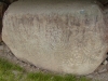


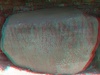
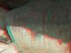
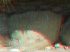
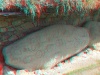
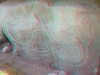
Thursday, 24th May 2012
Today I took some 3D photos of a few of the kerbstones. I hope they turn out ok. The sun was very bright, so it was difficult to get a good shot without a light and dark half!
Like this monument
Marked Sites
3D Anaglyph Images
Click Thumbnail to View Full Size Image
 _
_ _
_ _
_ _
_ _
_ _
_ _
_ _
_Directions
The rock art at Knowth can only be seen by attending an organised trip from the visitors center.
Random Gazetteer
A Selection of Other Rock Art
About Coordinates Displayed
|
This is an explanation of (and a bit of a disclaimer for) the coordinates I provide. Where a GPS figure is given this is the master for all other coordinates. According to my Garmin these are quite accurate. Where there is no GPS figure the 6 figure grid reference is master for the others. This may not be very accurate as it could have come from the OS maps and could have been read by eye. Consequently, all other cordinates are going to have inaccuracies. The calculation of Longitude and Latitude uses an algorithm that is not 100% accurate. The long/lat figures are used as a basis for calculating the UTM & ITM coordinates. Consequently, UTM & ITM coordinates are slightly out. UTM is a global coordinate system - Universal Transverse Mercator - that is at the core of the GPS system. ITM is the new coordinate system - Irish Transverse Mercator - that is more accurate and more GPS friendly than the Irish Grid Reference system. This will be used on the next generation of Irish OS maps. |


Page loaded from cache: (Generation time: January 17 2020 14:53:38.)