


Parknabinnia : Wedge Tomb
Visit Notes
Saturday, 26th October 2002
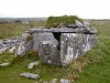
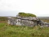
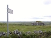
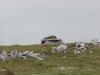
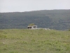
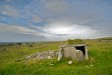
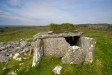
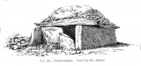
This is (see fig. the) Parknabinnia wedge tomb that is marked on so many tourist maps and it is one of many in the area. It is clearly signposted and very close to the road. It is also in amazing condition! In fact I would venture as far as to say it has to be one of the best in the area.
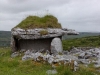
It is of the box style so popular in the Burren. The wonderfully large, single roof stone is over 3m in length and much of the cairn survives. All the slabs forming the walls are present. The est end (which is the front) was blocked by two slabs each covering one half of the entrance. This is a very common feature of the other tombs in the locale. One of these stones has been pulled forward in order to gain access.
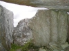
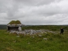
The grass covered roof has been displaced slightly, but the gallery is essentially still intact. The inner space is very good for providing shelter from the rain (of which I saw quite a lot this weekend). Of all the sites that I saw on this trip, this one has to be placed near the top of the 'must go back to' sites.
Sunday, 6th June 2004
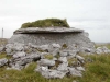
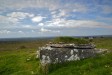
We had expected to come across a lot of people at Poulnabrone (County Clare) today (Bank Holiday weekend), but it was great to see so many people here. From this point on we were actually shadowed by a Spanish couple. The man was obviously very keen and went to some extremely obscure sites along this road; sites most people wouldn't bother with.
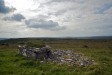
This is a very lovely monument. Special mention should be given to the huge erratic on the opposite side of the road. A line from this, through the tomb points straight at a rounded hillock to the west.
It is also notable that this tomb is aligned more north-south than east-west.
Click Thumbnail to View Full Size Image
_______
Sunday, 21st September 2008
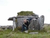
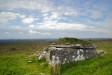
I had forgotten that I'd taken some new photos of this beautiful tomb as I was passing. This site really is so close to the road that it's a real shame it has not been made more accessible. It wouldn't take much effort to remove the style and put a gate in!
Click Thumbnail to View Full Size Image
______
Like this monument
Marked Sites
Site Plans
Click Thumbnail to View Full Size Image
 _
_ _
_Old Images
Click Thumbnail to View Full Size Image
 _
_Random Gazetteer
A Selection of Other Wedge Tombs
About Coordinates Displayed
|
This is an explanation of (and a bit of a disclaimer for) the coordinates I provide. Where a GPS figure is given this is the master for all other coordinates. According to my Garmin these are quite accurate. Where there is no GPS figure the 6 figure grid reference is master for the others. This may not be very accurate as it could have come from the OS maps and could have been read by eye. Consequently, all other cordinates are going to have inaccuracies. The calculation of Longitude and Latitude uses an algorithm that is not 100% accurate. The long/lat figures are used as a basis for calculating the UTM & ITM coordinates. Consequently, UTM & ITM coordinates are slightly out. UTM is a global coordinate system - Universal Transverse Mercator - that is at the core of the GPS system. ITM is the new coordinate system - Irish Transverse Mercator - that is more accurate and more GPS friendly than the Irish Grid Reference system. This will be used on the next generation of Irish OS maps. |


Page loaded from cache: (Generation time: January 17 2020 20:41:24.)