


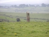
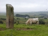
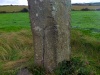
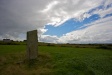
Breastagh : Ogham Stone
Visit Notes
Sunday, 4th August 2002
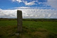
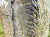
Now this is one mighty fine standing stone in its own right, but it is made more wonderful by the addition of some nearly legible ogham script.
The one side reads a fairly meaningless 'LGG ....... SD ...... LE ESIAD' and the other reads 'MAQ CORBBRI MAQ AMLOITT' (The Son of Corbbri, Son Of Amloitt).
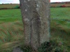
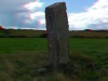
A nearby sign suggests a broad date range of 300-600 ce for the inscription and that the 3.5m tall, square sectioned, standing stone was probably erected in the bronze age.

Monday, 25th October 2004
The field was devoid of cows and bulls today, so I took Uta across to see this great stone. It was also a good excuse to take a GPS reading and see how Nephin features in its skyline. It doesn't. However, the nearby wedge tomb ( Breastagh (County Mayo)) is built so that Nephin is visible.


Saturday, 21st August 2010
I had meant to bring a copy of the old photo I have of this monument and perhaps try to recreate it. Two things stopped me doing so:
1) I forgot the photo
2) It was raining very heavily and the thick grass in the field was soaking wet
We still ventured to the stone, though, despite getting very soggy feet.
Click Thumbnail to View Full Size Image
______
Like this monument
Marked Sites
3D Anaglyph Images
Click Thumbnail to View Full Size Image
 _
_ _
_Old Images
Click Thumbnail to View Full Size Image
 _
_Directions
From Killala take the R314 north for around 4kms. Here the road turns sharp right, crosses a river and turns sharp left. At this bend carry straight on. Continue along this road for 2kms until you reach a cross roads. Carry straight on here for about 300m and you will see a sign post pointing into the field on the left.
Random Gazetteer
A Selection of Other Ogham Stones
About Coordinates Displayed
|
This is an explanation of (and a bit of a disclaimer for) the coordinates I provide. Where a GPS figure is given this is the master for all other coordinates. According to my Garmin these are quite accurate. Where there is no GPS figure the 6 figure grid reference is master for the others. This may not be very accurate as it could have come from the OS maps and could have been read by eye. Consequently, all other cordinates are going to have inaccuracies. The calculation of Longitude and Latitude uses an algorithm that is not 100% accurate. The long/lat figures are used as a basis for calculating the UTM & ITM coordinates. Consequently, UTM & ITM coordinates are slightly out. UTM is a global coordinate system - Universal Transverse Mercator - that is at the core of the GPS system. ITM is the new coordinate system - Irish Transverse Mercator - that is more accurate and more GPS friendly than the Irish Grid Reference system. This will be used on the next generation of Irish OS maps. |


Page loaded from cache: (Generation time: December 05 2019 13:30:18.)