


Coolasnaghta : Rock Art
Visit Notes
Friday, 29th March 2002
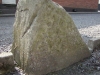
Easy to find but difficult to see! Well, that's how I found it. This small triangular stone stands in the front garden of the bungalow that is marked on the OS. It was found by the occupier whilst digging the foundations.
Sadly the markings are becomming very faint now, but they are extraordinary. There are at least 6 cup and ring marks (one surrounded by other smaller cups) and four X's. Two cup & rings are joined by one of the crosses.
Click Thumbnail to View Full Size Image
_
Like this monument
Marked Sites
Directions
Directions to this place are fairly cumbersome and so I will recommend that you get the OS map to help you. When you reach the cross roads you will find two small dwellings. The stone is in the front garden (3m from road and visible) of the house furthest from the cross roads.
Random Gazetteer
A Selection of Other Rock Art
About Coordinates Displayed
|
This is an explanation of (and a bit of a disclaimer for) the coordinates I provide. Where a GPS figure is given this is the master for all other coordinates. According to my Garmin these are quite accurate. Where there is no GPS figure the 6 figure grid reference is master for the others. This may not be very accurate as it could have come from the OS maps and could have been read by eye. Consequently, all other cordinates are going to have inaccuracies. The calculation of Longitude and Latitude uses an algorithm that is not 100% accurate. The long/lat figures are used as a basis for calculating the UTM & ITM coordinates. Consequently, UTM & ITM coordinates are slightly out. UTM is a global coordinate system - Universal Transverse Mercator - that is at the core of the GPS system. ITM is the new coordinate system - Irish Transverse Mercator - that is more accurate and more GPS friendly than the Irish Grid Reference system. This will be used on the next generation of Irish OS maps. |


Page loaded from cache: (Generation time: March 26 2020 12:17:34.)