


Keamcorravooley : Wedge Tomb
Visit Notes
Sunday, 14th September 2003
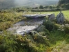
I was instantly reminded of Altar (County Cork) when I first saw this monument. It is very similar. Two slightly overlapping roofstones cover the gallery . I was very disappointed, however, to find the tomb buried in brambles. I was not surprised by this though - I've become used to it. When will people start to care for these ancient structures again? Probably never, because there's no money in it.
If cleared it would be a very good example of a wedge tomb . That is to say that it is a very good example - you just can't see that it is at the moment. Because this one has not been reconstructed it has a lot more character than Altar. If the brambles were just cleared off it then it would be a very visitable site.
This is the northern most of two tombs in this townland. I could not locate the other tomb (just 200m away). I think it is now totally hidden.


Like this monument
Marked Sites
Old Images
Click Thumbnail to View Full Size Image
 _
_ _
_Random Gazetteer
A Selection of Other Wedge Tombs
About Coordinates Displayed
|
This is an explanation of (and a bit of a disclaimer for) the coordinates I provide. Where a GPS figure is given this is the master for all other coordinates. According to my Garmin these are quite accurate. Where there is no GPS figure the 6 figure grid reference is master for the others. This may not be very accurate as it could have come from the OS maps and could have been read by eye. Consequently, all other cordinates are going to have inaccuracies. The calculation of Longitude and Latitude uses an algorithm that is not 100% accurate. The long/lat figures are used as a basis for calculating the UTM & ITM coordinates. Consequently, UTM & ITM coordinates are slightly out. UTM is a global coordinate system - Universal Transverse Mercator - that is at the core of the GPS system. ITM is the new coordinate system - Irish Transverse Mercator - that is more accurate and more GPS friendly than the Irish Grid Reference system. This will be used on the next generation of Irish OS maps. |


Page loaded from cache: (Generation time: January 29 2020 16:39:59.)