


'Templecronan' : Church
This site has subsites
| Termon - Holy Well |
Visit Notes
Sunday, 27th October 2002
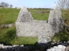
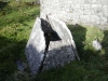
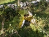
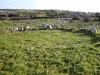
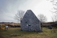
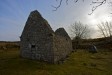
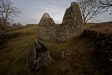
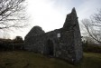
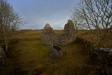
This little church is a delight. Just for its location alone it is lovely, nestled in a sleepy little hollow, hidden from the world. Situated at the east end are two battered tomb shrines, one nest to the south east corner and a smaller one just over the field wall. These are both triangular in section and resemble tents and are probably much older than the church itself. The larger one of these is the Bed of St. Cronan and would have once contained his bones, making this site a place of pilgramage, and hence the building of the church.
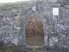
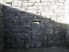
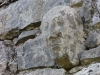
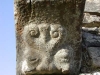
The original door in the east wall has been blocked up, but its typical sloping sides and large lintel are clearly visible. Around the outside are some lovely Romanesque corbels of heads and beasties and the inside of the east window is also decorated with some beads.
Click Thumbnail to View Full Size Image
________
Wednesday, 17th March 2010
I was so happy to be able to come back here. The site is still such a delight to be at. The seclusion and tranquility are simply superb.
Someone has been surveying the site. At the time of this visit there was a chalk line going right around the building, inside and out, and there were several wooden pegs around the enclosure. I know it's nice to have these places recorded, but should this be allowed? If I chalked my name on the walls I'd be called a vandal!
Click Thumbnail to View Full Size Image
_________
Like this monument
Marked Sites
3D Anaglyph Images
Click Thumbnail to View Full Size Image
 _
_ _
_3D Animations
Click Thumbnail to View Full Size Image
 _
_Random Gazetteer
A Selection of Other Churches
About Coordinates Displayed
|
This is an explanation of (and a bit of a disclaimer for) the coordinates I provide. Where a GPS figure is given this is the master for all other coordinates. According to my Garmin these are quite accurate. Where there is no GPS figure the 6 figure grid reference is master for the others. This may not be very accurate as it could have come from the OS maps and could have been read by eye. Consequently, all other cordinates are going to have inaccuracies. The calculation of Longitude and Latitude uses an algorithm that is not 100% accurate. The long/lat figures are used as a basis for calculating the UTM & ITM coordinates. Consequently, UTM & ITM coordinates are slightly out. UTM is a global coordinate system - Universal Transverse Mercator - that is at the core of the GPS system. ITM is the new coordinate system - Irish Transverse Mercator - that is more accurate and more GPS friendly than the Irish Grid Reference system. This will be used on the next generation of Irish OS maps. |


Page loaded from cache: (Generation time: January 17 2020 16:13:06.)