


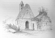
'St. Kevin's Chapel' : Church
This is a subsite of:
This site has subsites
| Glendalough - Bullaun Stone |
Visit Notes
Saturday, 16th March 2002
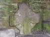
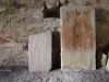
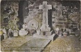
A strange little chapel nestled in the dip below the cathedral. Now gated shut it is used as a store house for bits of broken building. In there at the time of my visit was a cross and Viking altar top both from Reefert Church (County Wicklow).
This was a two story building and the upper floor would have been home to one of the monks and his wife. Yes, the Irish did things a little differently before Rome got involved.
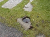
Outside to the north is a small bullaun stone set into the ground, nearly overgrown. The one to the south seems to be covered or missing.
Sunday, 22nd June 2003
I'm not going to mention everything we went to again at Glendalough, but I will add a little note here, because we arrived just as a tour was leaving the building and we able to slip in quickly.
My main wish was to see the graveslabs and altar top properly, which I did. The altar top, originally from Refert church, is quite spectacular, with incised diamonds meeting at concentric circles.
Click Thumbnail to View Full Size Image
_
Like this monument
Marked Sites
Old Images
Click Thumbnail to View Full Size Image
 _
_ _
_Directions
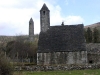
This little chapel is situated in a dip between the cathedral and the river and visible from the cathedral.
Miscellanea
Sometimes called St. Kevin's Kitchen perhaps due to its diminutive size and/or the chimney like bell tower.
Random Gazetteer
A Selection of Other Churches
About Coordinates Displayed
|
This is an explanation of (and a bit of a disclaimer for) the coordinates I provide. Where a GPS figure is given this is the master for all other coordinates. According to my Garmin these are quite accurate. Where there is no GPS figure the 6 figure grid reference is master for the others. This may not be very accurate as it could have come from the OS maps and could have been read by eye. Consequently, all other cordinates are going to have inaccuracies. The calculation of Longitude and Latitude uses an algorithm that is not 100% accurate. The long/lat figures are used as a basis for calculating the UTM & ITM coordinates. Consequently, UTM & ITM coordinates are slightly out. UTM is a global coordinate system - Universal Transverse Mercator - that is at the core of the GPS system. ITM is the new coordinate system - Irish Transverse Mercator - that is more accurate and more GPS friendly than the Irish Grid Reference system. This will be used on the next generation of Irish OS maps. |


Page loaded from cache: (Generation time: January 17 2020 21:36:29.)