


Moone : High Cross
Visit Notes
Sunday, 10th March 2002
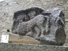
Take me to the Moone!! What a cross! But first the broken fragments of the second cross. This small cross would have been very nice indeed, lots of beasties and a delicate celtic circle.
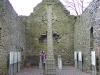
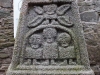
Now the big cross. This one truly is a HIGH cross. 5m high worth of high cross and one of the most spectacular you will see anywhere. I don't know where it was originally sited but it is now inside the ruins of a church, giving some protection, surrounded by informative notices about the carvings.
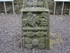
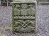
As usual there are beautifully carved vignettes of scenes from biblical stories, but as an added bonus there are serpents and multi headed monsters here too.
Take a look at some of the photos and tell me you don't want to see this wonder. Bet you can't.
Click Thumbnail to View Full Size Image
_______

Sunday, 14th April 2002
If you are going to take friends to a high cross then take them to Moone. This 6m monster can not fail to impress.
Sunday, 17th July 2005
There were loads of people here today, which is great to see. Another pleasant surprise for me was that there is now a roof over the church giving the cross and fragments some protection from the elements. It's not the prettiest roof in the world, but it's there and that's what counts.
The roof is very effective. It is made of a see-through plasstic which disperses the light quite evenly about the inside of the church building. Surprisingly the cross looks very good in these ambient conditions.


Sunday, 14th February 2010
My daughter was with me today and, after getting lost on the newly opened stretch of the M9, we found ourselves near Moone. She has studied Moone high cross for her leaving cert, but never seen it, so we stopped to take a look. As expected, she was surprised at exactly how tall it is. Reading about a place sometimes just doesn't do it justice.
I also wanted to try out my new 3D camera to see how well it picked up the detail on the cross. This monument will be the first on megalithomania to have a 3D image posted. All I have to do now is alter the code to show them.
Like this monument
Marked Sites
3D Anaglyph Images
Click Thumbnail to View Full Size Image
 _
_ _
_3D Animations
Click Thumbnail to View Full Size Image
 _
_Old Images
Click Thumbnail to View Full Size Image
 _
_Directions
From Killcullen take the N9 south and turn right into Ballitore. Carry on through until you reach a t-junction and turn left. Take the next left and follow this road south. At around 3.5km you will see the cross signposted through a gap in the wall to the right.
Random Gazetteer
A Selection of Other High Crosses
About Coordinates Displayed
|
This is an explanation of (and a bit of a disclaimer for) the coordinates I provide. Where a GPS figure is given this is the master for all other coordinates. According to my Garmin these are quite accurate. Where there is no GPS figure the 6 figure grid reference is master for the others. This may not be very accurate as it could have come from the OS maps and could have been read by eye. Consequently, all other cordinates are going to have inaccuracies. The calculation of Longitude and Latitude uses an algorithm that is not 100% accurate. The long/lat figures are used as a basis for calculating the UTM & ITM coordinates. Consequently, UTM & ITM coordinates are slightly out. UTM is a global coordinate system - Universal Transverse Mercator - that is at the core of the GPS system. ITM is the new coordinate system - Irish Transverse Mercator - that is more accurate and more GPS friendly than the Irish Grid Reference system. This will be used on the next generation of Irish OS maps. |


Page loaded from cache: (Generation time: January 17 2020 21:35:57.)