


Inishkeel : Cross Pillar
Visit Notes
Thursday, 29th July 2010
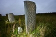
This broken cross pillar stands about 1.4m tall, but once stood taller. At the top you can see that it once flared out, so it was probably a proper cross. The east face is beautifully decorated with a Celtic knot pattern that covers all but a slim border around the edge of the shaft.
Note: Inishkeel can be accessed at low tide by walking across 800m of exposed beach, but do check the lengths of the low tide before crossing over.
Like this monument
Marked Sites
3D Anaglyph Images
Click Thumbnail to View Full Size Image
 _
_Random Gazetteer
A Selection of Other Cross Pillars
About Coordinates Displayed
|
This is an explanation of (and a bit of a disclaimer for) the coordinates I provide. Where a GPS figure is given this is the master for all other coordinates. According to my Garmin these are quite accurate. Where there is no GPS figure the 6 figure grid reference is master for the others. This may not be very accurate as it could have come from the OS maps and could have been read by eye. Consequently, all other cordinates are going to have inaccuracies. The calculation of Longitude and Latitude uses an algorithm that is not 100% accurate. The long/lat figures are used as a basis for calculating the UTM & ITM coordinates. Consequently, UTM & ITM coordinates are slightly out. UTM is a global coordinate system - Universal Transverse Mercator - that is at the core of the GPS system. ITM is the new coordinate system - Irish Transverse Mercator - that is more accurate and more GPS friendly than the Irish Grid Reference system. This will be used on the next generation of Irish OS maps. |


Page loaded from cache: (Generation time: January 17 2020 20:33:06.)