


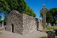
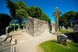
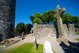
'The West Cross' : High Cross
This is a subsite of:
Visit Notes
Saturday, 8th May 2010
This tall, elegant cross has seen better days. The weather has really eaten away at the shaft, especially near the base. This cross is often overlooked because of the other cross in the graveyard, Muiredach's Cross (County Louth), but this is a little unfair. If this stood alone at a site it would be praised for its beauty.
It stands just shy of 7m tall and is capped by a representation of an early church. The east and west face are typically decorated with biblical scenes, while the north and south faces has biblical scenes and Celtic patterns.
Panels on the east face include: The Sacrifice of Isaac, Daniel and the Lion, The Fall of Simon Magus, Goliath, and David with the head of Goliath.
On the west face you can see: The Baptism of Christ, The Kiss of Judas, The Mocking of Christ, The Arrest of Christ, and the Crucifixion.
As well as the Celtic ornamentation, the north and south faces have a couple of the scenes you would normally see on the east and west faces: The Flight into Egypt, and The Temptation of St. Anthony.
Click Thumbnail to View Full Size Image
_______
Like this monument
Marked Sites
3D Anaglyph Images
Click Thumbnail to View Full Size Image
 _
_3D Animations
Click Thumbnail to View Full Size Image
 _
_ _
_Random Gazetteer
A Selection of Other High Crosses
About Coordinates Displayed
|
This is an explanation of (and a bit of a disclaimer for) the coordinates I provide. Where a GPS figure is given this is the master for all other coordinates. According to my Garmin these are quite accurate. Where there is no GPS figure the 6 figure grid reference is master for the others. This may not be very accurate as it could have come from the OS maps and could have been read by eye. Consequently, all other cordinates are going to have inaccuracies. The calculation of Longitude and Latitude uses an algorithm that is not 100% accurate. The long/lat figures are used as a basis for calculating the UTM & ITM coordinates. Consequently, UTM & ITM coordinates are slightly out. UTM is a global coordinate system - Universal Transverse Mercator - that is at the core of the GPS system. ITM is the new coordinate system - Irish Transverse Mercator - that is more accurate and more GPS friendly than the Irish Grid Reference system. This will be used on the next generation of Irish OS maps. |


Page loaded from cache: (Generation time: January 18 2020 01:10:45.)