


Fanygalvan : Wedge Tomb
This site has subsites
| Cahermackirilla - Stone Row or Alignment | Cahermackirilla - Hut Circle |
| Cahermackirilla - Cairn | Fanygalvan - Chambered Cairn |
Visit Notes
Wednesday, 17th March 2010
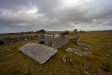
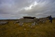
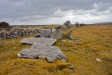
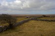
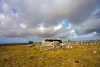
This hilltop wedge tomb can be thought of as the centrepiece of a wonderful complex of monuments. Nearby there are , hut circles, a cairn, a stone row and a chambered cairn with an exposed cist .
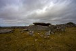
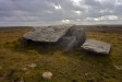
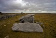
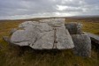
The wedge tomb is a large example, with a 6m long gallery that faces west. Each side of the gallery is formed using two slabs, almost as if it was extended at some point with two 1m long sections. The large wallslab on the northside has collapsed inwards to about 45 degrees and is supported within the gallery by a small stone. This collapse gives the massive roofslab a steep slope. The roofslab has also broken in two, with the front 1.5m of it lying on the ground in front of the gallery. When complete the roofslab would have weighed somewhere in the region of 10 tons.
At the front of the gallery the front slab is still in situ. This does not fill the whole width of the gallery. On the southern side in particular the remans of the double walling are good. The massive roofslab would not have covered the extra back sections of the walls, again maybe pointing to these being a later extension.
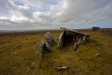
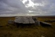
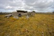
It appears that there are actually two wedge tombs here forming one monument. A few metres to the west of the main structure there is another small, collapsed monument. The roofslab of this is around 2.5m x 1m, and it lies on top of some smaller slabs. This structure does not appear to have shared the same axis as the main monument.
NOTE: The wall that lies just north of the wedge tomb is actually the townland boundary, so a few of the monuments here are in Cahermackirilla townland, not Fanygalvan.
Click Thumbnail to View Full Size Image
______________
Like this monument
Marked Sites
3D Anaglyph Images
Click Thumbnail to View Full Size Image
 _
_ _
_3D Animations
Click Thumbnail to View Full Size Image
 _
_ _
_Random Gazetteer
A Selection of Other Wedge Tombs
About Coordinates Displayed
|
This is an explanation of (and a bit of a disclaimer for) the coordinates I provide. Where a GPS figure is given this is the master for all other coordinates. According to my Garmin these are quite accurate. Where there is no GPS figure the 6 figure grid reference is master for the others. This may not be very accurate as it could have come from the OS maps and could have been read by eye. Consequently, all other cordinates are going to have inaccuracies. The calculation of Longitude and Latitude uses an algorithm that is not 100% accurate. The long/lat figures are used as a basis for calculating the UTM & ITM coordinates. Consequently, UTM & ITM coordinates are slightly out. UTM is a global coordinate system - Universal Transverse Mercator - that is at the core of the GPS system. ITM is the new coordinate system - Irish Transverse Mercator - that is more accurate and more GPS friendly than the Irish Grid Reference system. This will be used on the next generation of Irish OS maps. |


Page loaded from cache: (Generation time: January 17 2020 22:49:08.)