


Carrowleagh : Court Tomb
Visit Notes
Saturday, 7th June 2008
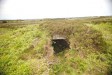
This site is a must-see for anyone interested in megalithic monuments. The problem is that it's very hard to locate! This is because it is completely buried in peat. Without a GPS visitors will need local help to find the tomb. It is best to go on a Saturday, when there will probably be someone cutting peat nearby.
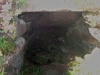
The court is still mainly buried below the peat and is not visible. Here and there the top of a stone pokes through, but these may not be from the structure. There is a large exposed stone set opposite the gallery entrance in a position I have never seen a stone before.
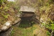
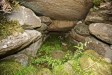
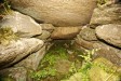
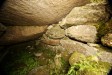
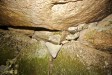
The gallery is almost complete: just one out of the three probable roofstones seems to have been removed. The two remaining roofstones are massive. These are supported by corbelling formed from split boulders. The gaps between these are plugged up with well-fitting stones in a most expert fashion. The coorbelling rests on the vertical wallstones, which are about 50cm tall. The height of the chamber is around 1.7m with the extra height being provided by the corbelling.
More often than not, when you visit a court tomb all you see is the low wallstones, and you wonder how such a low structure could have been used. Seeing the inside of this near-perfect tomb shows you that most court tombs would not have been low structures at all.
Click Thumbnail to View Full Size Image
_______

Saturday, 21st August 2010
I managed to find the site very quickly this time, but the peat was very wet in places and we had to take a bit of a detour and do some scrambling up and down 1.2m banks.
Tatjana was very impressed by the state of preservation of this amazing monument, and who wouldn't be? The corbelling visible in the rear of the gallery is unmatched in an open tomb.
Click Thumbnail to View Full Size Image
_
Like this monument
Marked Sites
3D Anaglyph Images
Click Thumbnail to View Full Size Image
 _
_Random Gazetteer
A Selection of Other Court Tombs
About Coordinates Displayed
|
This is an explanation of (and a bit of a disclaimer for) the coordinates I provide. Where a GPS figure is given this is the master for all other coordinates. According to my Garmin these are quite accurate. Where there is no GPS figure the 6 figure grid reference is master for the others. This may not be very accurate as it could have come from the OS maps and could have been read by eye. Consequently, all other cordinates are going to have inaccuracies. The calculation of Longitude and Latitude uses an algorithm that is not 100% accurate. The long/lat figures are used as a basis for calculating the UTM & ITM coordinates. Consequently, UTM & ITM coordinates are slightly out. UTM is a global coordinate system - Universal Transverse Mercator - that is at the core of the GPS system. ITM is the new coordinate system - Irish Transverse Mercator - that is more accurate and more GPS friendly than the Irish Grid Reference system. This will be used on the next generation of Irish OS maps. |


Page loaded from cache: (Generation time: January 17 2020 15:04:12.)